List of Air Monitors Imperial

Select the monitor name to view more air quality data for that location. Find out what the Community Air-Quality Level colors and numbers mean.

Monitor list

64 of 104 monitors shown

City/Area Location Value Indicator
City/Area Calexico, CA Location Dogwood Rd & HWY 98 Value

116

Indicator CAL
City/Area Calexico, CA Location Calexico Airport Value

108

Indicator CAL
City/Area Avenal, CA Location Hilltop, Avenal Value

92

Indicator CAL
City/Area Calexico, CA Location East Birch Street and Andrade Avenue Value

83

Indicator CAL
City/Area Calexico, CA Location Housing Authority West Value

82

Indicator CAL
City/Area Mexicali, B.C. Location Instituto Tecnológico de Mexicali Value

79

Indicator CAL
City/Area Calexico, CA Location SDSU Calexico Value

77

Indicator CAL
City/Area Calexico, CA Location Rivera St Value

75

Indicator CAL
City/Area El Centro, CA Location Sunflower Elementary School Value

73

Indicator CAL
City/Area Mexicali Location Mexicali - González Ortega Value

72

Indicator AQI
City/Area Seeley, CA Location Seeley Elementary School Value

69

Indicator CAL
City/Area Calexico, CA Location Housing Authority East Value

69

Indicator CAL
City/Area Salton Sea Beach, CA Location Torres Martinez Salton Sea Beach Value

68

Indicator AQI
City/Area Mexicali, B.C. Location Mexicali - Villafontana Value

67

Indicator CAL
City/Area El Centro, CA Location Betty Jo McNeece Receiving Home Value

66

Indicator CAL
City/Area Calexico, CA Location Calexico North Value

66

Indicator CAL
City/Area Heber, CA Location Dogwood School Value

65

Indicator CAL
City/Area El Centro, CA Location Desert Garden Elementary School Value

64

Indicator CAL
City/Area El Centro, CA Location Lincoln Elementary School Value

63

Indicator CAL
City/Area El Centro, CA Location Imperial County Air Pollution Control District Value

63

Indicator CAL
City/Area Imperial, CA Location TL Waggoner Elementary School Value

60

Indicator CAL
City/Area Heber, CA Location Heber Elementary School Value

57

Indicator CAL
City/Area Thermal, CA Location Torres Martinez Administration Building Value

57

Indicator AQI
City/Area El Centro, CA Location Gio’s Mobile Home Estates Value

56

Indicator CAL
City/Area El Centro, CA Location De Anza Magnet School Value

55

Indicator CAL
City/Area El Centro, CA Location Kennedy Middle School Value

55

Indicator CAL
City/Area El Centro, CA Location Wilson Jr High School Value

55

Indicator CAL
City/Area Mexicali Location Mexicali East Value

55

Indicator AQI
City/Area Bonds Corner, CA Location Miller Road And Verde School Road Value

53

Indicator CAL
City/Area El Centro, CA Location Booker T. Washington Elementary Value

52

Indicator CAL
City/Area Riverside, CA Location CARB Riverside HQ Value

48

Indicator CAL
City/Area Thermal, CA Location Desert Mirage High School Value

45

Indicator CAL
City/Area Thermal, CA Location Salton City Value

43

Indicator CAL
City/Area Mecca, CA Location Torres-Martinez Reservation Value

41

Indicator CAL
City/Area El Centro, CA Location Meadows Union Elementary School Value

40

Indicator CAL
City/Area Brawley, CA Location Comite Civico Del Valle Offices Value

37

Indicator CAL
City/Area Seeley, CA Location Seeley West Value

37

Indicator AQI
City/Area El Centro, CA Location Wake Ave & Weakley St Value

35

Indicator CAL
City/Area Salton City, CA Location Naval Test Base Value

34

Indicator CAL
City/Area Westmorland, CA Location Westmorland Union Elementary School Value

33

Indicator CAL
City/Area Calipatria, CA Location Calipatria East Value

33

Indicator CAL
City/Area Coachella, CA Location Ave. 52 & Cypress Street Value

32

Indicator CAL
City/Area Brawley, CA Location Miguel Hidalgo Elementary School Value

32

Indicator CAL
City/Area Holtville, CA Location Holtville High School Value

32

Indicator CAL
City/Area Riverside, CA Location CARB Riverside HQ #2 Value

32

Indicator CAL
City/Area Mecca, CA Location Lookout Drive & Harbor Drive Value

29

Indicator CAL
City/Area Mecca, CA Location North Shore State Park Road Near Parkside Drive Value

29

Indicator CAL
City/Area Calexico, CA Location Mets Road And West Heber Road Value

29

Indicator CAL
City/Area Niland, CA Location Grace Smith Elementary School Value

28

Indicator CAL
City/Area Brawley, CA Location Andre Road And Pellett Road Value

27

Indicator CAL
City/Area Calipatria, CA Location Calipatria Unified School District Value

27

Indicator CAL
City/Area Brawley, CA Location North 11th Street And River Drive Value

27

Indicator CAL
City/Area Brawley, CA Location Comite Civico Del Valle Offices Value

27

Indicator AQI
City/Area Ocotillo, CA Location Agate Road And Imperial Highway Value

26

Indicator CAL
City/Area Brawley, CA Location Brawley Union High School Value

23

Indicator CAL
City/Area Mecca, CA Location Grapefruit Blvd and Garfield St Value

23

Indicator CAL
City/Area Indio, CA Location Indio Value

23

Indicator AQI
City/Area Imperial, CA Location Brushwood Value

19

Indicator AQI
City/Area Westmorland, CA Location Lack Road And Walker Road Value

18

Indicator CAL
City/Area Avenal, CA Location Senior Center, Avenal Value

15

Indicator CAL
City/Area Niland, CA Location North Niland Value

12

Indicator AQI
City/Area El Centro, CA Location S 4th Street & W Holt Ave Value

8

Indicator CAL
City/Area Calipatria, CA Location Sonny Bono Wildlife Refuge Value

0

Indicator CAL
City/Area Thermal, CA Location Oasis Elementary Value

0

Indicator CAL
City/Area Shafter, CA Location Shafter Monitor Value

offline

Indicator CAL
City/Area San Francisco, CA Location KIPP Academy (College Prep) Value

offline

Indicator CAL
City/Area San Francisco, CA Location Bayview Opera House Value

offline

Indicator CAL
City/Area San Francisco, CA Location Ingalls Ave and Ingerson St Value

offline

Indicator CAL
City/Area Arvin, CA Location Arvin Value

offline

Indicator CAL
City/Area Calexico, CA Location Alvarez Tax Service Value

offline

Indicator CAL
City/Area Niland, CA Location Bombay Beach Value

offline

Indicator CAL
City/Area Imperial, CA Location Frank Wright Middle School Value

offline

Indicator CAL
City/Area Riverdale, CA Location Lanare Community Center Value

offline

Indicator CAL
City/Area Coachella, CA Location Cesar Chavez Elementary School Value

offline

Indicator CAL
City/Area Coalinga, CA Location Coalinguita Ranch Value

offline

Indicator CAL
City/Area Coalinga, CA Location Mobile Home Park Value

offline

Indicator CAL
City/Area Raisin City, CA Location Raisin City Elementary Value

offline

Indicator CAL
City/Area Firebaugh, CA Location Dunkle Park Value

offline

Indicator CAL
City/Area Huron, CA Location The LEAP Institute Value

offline

Indicator CAL
City/Area San Francisco, CA Location Banya Archimedes Value

offline

Indicator CAL
City/Area Hanford, CA Location KCAO Rosa Park Learning Center Value

offline

Indicator CAL
City/Area Armona, CA Location Kings Cultural Center Value

offline

Indicator CAL
City/Area Five Points, CA Location Westside Elementary Value

offline

Indicator CAL
City/Area San Joaquin, CA Location San Joaquin Value

offline

Indicator CAL
City/Area Avenal, CA Location Avenal Community Garden Value

offline

Indicator CAL
City/Area Lemoore, CA Location West Hills College Value

offline

Indicator CAL
City/Area Coalinga, CA Location Monroe St Value

offline

Indicator CAL
City/Area Avenal, CA Location District Office, Avenal Value

offline

Indicator CAL
City/Area Corcoran, CA Location Corcoran Value

offline

Indicator CAL
City/Area Kettleman City, CA Location Kettleman City Value

offline

Indicator CAL
City/Area Mendota, CA Location Mendota Value

offline

Indicator CAL
City/Area Stratford, CA Location Stratford Value

offline

Indicator CAL
City/Area Coalinga, CA Location Coalinga Value

offline

Indicator CAL
City/Area San Francisco, CA Location True Hope Church Value

offline

Indicator CAL
City/Area San Francisco, CA Location Rebecca and Keith Site Value

offline

Indicator CAL
City/Area San Francisco, CA Location Revere and Jennings Site Value

offline

Indicator CAL
City/Area San Francisco, CA Location Arkansas Street Calibration Site Value

offline

Indicator CAL
City/Area Terra Bella, CA Location Terra Bella Community Value

offline

Indicator CAL
City/Area Cutler, CA Location Ave 407 Value

offline

Indicator CAL
City/Area Riverdale, CA Location Riverdale Value

offline

Indicator CAL
City/Area Arvin, CA Location Arvin Value

offline

Indicator CAL
City/Area Avenal, CA Location District Office Value

offline

Indicator CAL
City/Area Buttonwillow, CA Location Buttonwillow community monitor Value

offline

Indicator CAL
City/Area Heber, CA Location Heber Value

Offline

Indicator AQI

About CALs

Community Air-Quality Levels (CALs) are used to describe air quality in terms of how harmful the level of particulate matter (PM) pollution in the air is to human health. The CALs are derived using similar methods as EPA’s Air Quality Index (AQI).

You should use both IVAN Air Monitoring and government air data to understand the air quality levels around you. When comparing health recommendations from both sources, you should follow the most health protective recommendation.

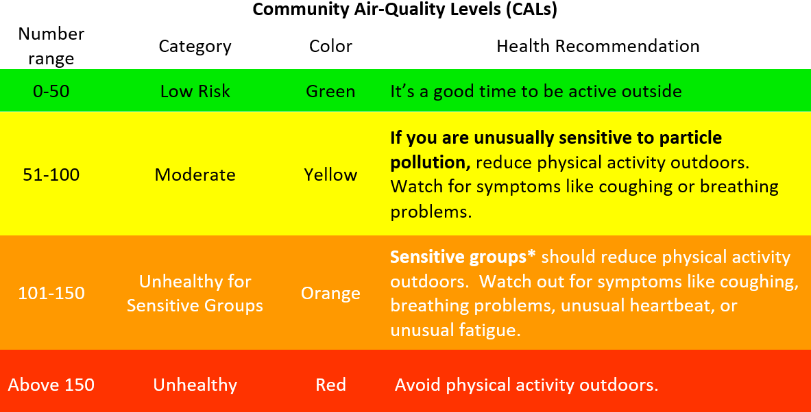
*Sensitive groups include children, teens, older adults, pregnant women, and people with heart, lung, or other chronic diseases

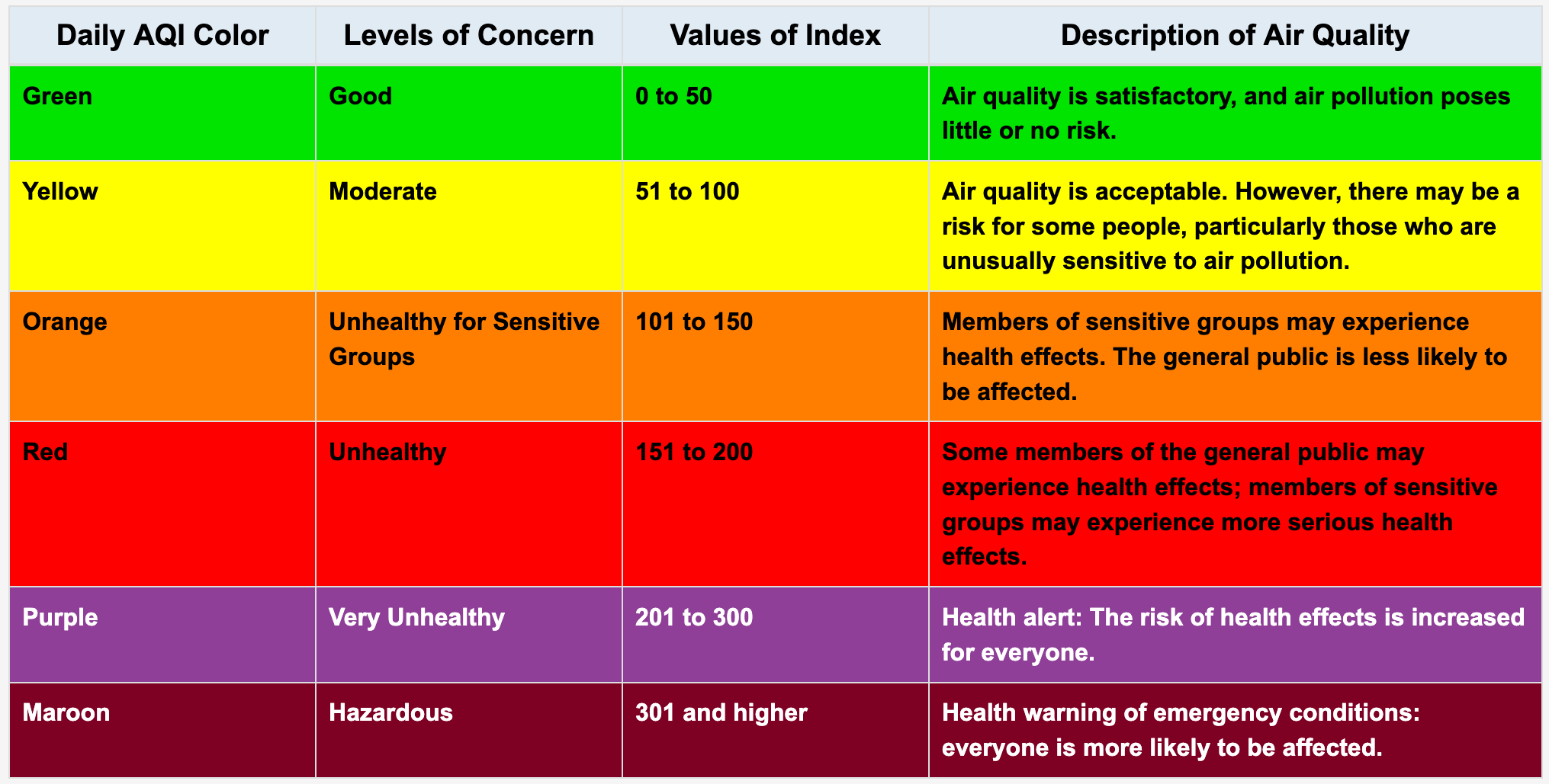
Air Quality Index (AQI) Basics

What is the U.S. Air Quality Index (AQI)?

The U.S. AQI is EPA's index for reporting air quality.

How does the AQI work?

The U.S. Air Quality Index (AQI) is EPA's tool for communicating about outdoor air quality and health. The AQI includes six color-coded categories, each corresponding to a range of index values. The higher the AQI value, the greater the level of air pollution and the greater the health concern. For example, an AQI value of 50 or below represents good air quality, while an AQI value over 300 represents hazardous air quality.

For each pollutant an AQI value of 100 generally corresponds to an ambient air concentration that equals the level of the short-term national ambient air quality standard for protection of public health. AQI values at or below 100 are generally thought of as satisfactory. When AQI values are above 100, air quality is unhealthy: at first for certain sensitive groups of people, then for everyone as AQI values get higher.

The AQI is divided into six categories. Each category corresponds to a different level of health concern. Each category also has a specific color. The color makes it easy for people to quickly determine whether air quality is reaching unhealthy levels in their communities.

AQI Basics for Ozone and Particle Pollution

AQI Basics for Ozone and Particle Pollution

Disclaimer

When using this information, please note the following:

  • In order to provide air quality information in real time, the data presented on this website are not validated or verified
  • The air quality levels are for particulate matter (PM) only. Other air pollutants, such as ozone, may be present, even when PM levels are low.
  • These data do not come from regulatory monitors and cannot be used to infer violations of the law
  • Data on this website should be considered preliminary and used with discretion

Learn more about our monitor validation process, how to use the data on this website, and how to compare the data with government

More info

View the Air Monitoring Q&A for more information on the following topics:

Government air data

Air quality data for Imperial County currently reported by government regulatory air monitors are available at www.imperialvalleyair.org and www.co.imperial.ca.us/AirPollution.

Data reported by IVAN Air Monitoring and by government monitors should both be used to better understand air quality levels near you. There are differences in how these data are collected, such as the locations monitored, the equipment used, and pollutants measured. Therefore, differences in reported air data are expected. When considering how to best protect your health, we recommended you consider multiple sources of air quality data and follow the most health protective recommendations.

Visit the Air Monitoring FAQs for more information about how our data compares with government data.

Report an air problem

If you are experiencing an emergency, call 9-1-1.

Step 1. Report to Imperial County Air Pollution Control District.

Call (442) 265-1800 as soon as you notice a problem with air quality. Their website lists what information to provide in order to support their investigations. It also describes what to expect when you submit a complaint.

Step 2. Report on IVAN.

After contacting the APCD, we recommend that you also submit a record of the problem here on IVAN Imperial, including a note that APCD has been contacted. This ensures that the Environmental Justice Task Force is aware of the complaint and that the complaint is documented on the IVAN Imperial website.

Copyright © 2008 - 2026 IVAN - All Rights Reserved

© HTML5UP.net. All Rights Reserved

Comite Civico del Valle, Inc